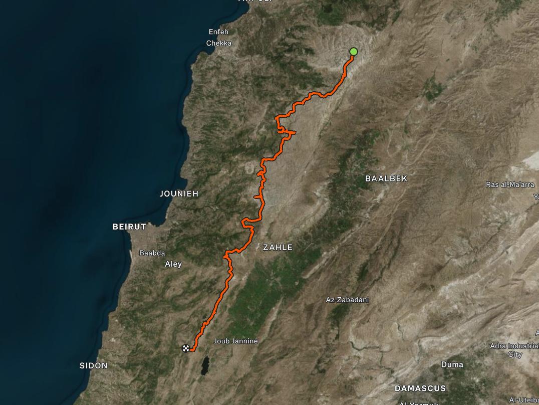
Lebanon is crossed by mountains, but most hiking events explore them one destination at a time.
In 2026, Highlanders961 chose a bigger challenge: hiking across Lebanon’s highlands section by section, creating a north-to-south mountain journey from Black Peak to Jezzine.
This is not one continuous hike, and it is not a new version of the Lebanon Mountain Trail.
It is a Highlanders961 project made up of separate mountain traverses. Each section has its own distance, elevation, terrain and difficulty. Together, these hikes reveal how Lebanon’s northern peaks, the Mount Lebanon range, the Chouf highlands and the mountains of Jezzine are connected.
By the end of the project, our hikers will have covered approximately 190 kilometres across Lebanon’s mountains.
The journey begins around Black Peak and the Cedars of Lebanon, where the landscape is high, exposed and demanding.
This northern region is defined by bare ridges, deep valleys, rocky terrain and some of the most dramatic mountain views in Lebanon.
From there, our hikes cross sections around:
Qornet El Sawda
Nassef El Batrak
Laqlouq
Aaqoura
These are not casual nature walks.
The northern mountains require endurance, steady movement and the ability to handle long distances, rocky surfaces, high altitude and changing weather conditions.
Each completed section adds another piece to the route. One hike may end in a particular mountain area, while another event continues the journey from a nearby point.
The objective is not to rush from north to south in one expedition. It is to explore every region properly while gradually creating a real hiking line across Lebanon.
The journey continues through the highlands of Aaqoura, Faraya and Mzaar Kfardebian—one of the most recognizable mountain regions in Lebanon.
Here, the route moves between agricultural plateaus, limestone formations, ski slopes and exposed ridgelines.
The views are wide, but the terrain remains physically demanding.
One of the project’s longest traverses covered approximately 30 kilometres between Faraya and Aaqoura. Other sections connect the surrounding highlands in different directions, allowing the complete mountain line to take shape across multiple hiking events.
Distance alone does not determine the difficulty of these trails. Elevation gain, altitude, terrain, exposure and pace all contribute to the real physical effort required.
Moving south, the project reaches Mount Sannine, one of Lebanon’s most important and recognizable mountains.
Sannine is more than a single summit. Its slopes, ridges and plateaus form a natural bridge between the northern and central sections of the Mount Lebanon range.
From Sannine, the journey continues across the central highlands toward:
Zaarour
Majdal Tarshish
Knaisseh
Falougha
These traverses take hikers across open ridgelines, high plateaus and constantly changing mountain terrain.
From different points along the route, the Mediterranean coast appears to the west while the Bekaa Valley opens to the east.
This central stage reveals the real scale of the project. Places that appear isolated on a map become part of a much larger mountain corridor once the trails between them are crossed.
South of the Beirut–Damascus corridor, the character of the landscape begins to change as the route enters the Chouf highlands.
The journey passes through mountain areas such as:
Dahr El Baidar
Ain Zhalta
Barouk
Maasser El Chouf
Mresti
Jbaa El Chouf
The Chouf combines open ridgelines, cedar forests, traditional villages and panoramic views across Lebanon.
From its higher sections, hikers can look west across the Chouf mountains and toward the Mediterranean. To the east, the Bekaa Valley opens below, with Qaraoun Lake visible in the distance on clear days.
Several of these hikes take place within or around the Shouf Biosphere Reserve, home to some of Lebanon’s most important cedar forests and protected natural landscapes.
Respecting the trails, wildlife and natural environment is an essential part of every crossing.
From the southern Chouf, the mountain line continues toward Jbaa El Chouf and Jezzine.
This final direction brings the project into a greener landscape shaped by forested slopes, rocky cliffs, deep valleys and villages overlooking South Lebanon.
Reaching Jezzine is not only about arriving at another hiking destination.
It completes the idea behind the project: experiencing Lebanon as one connected mountain landscape rather than a collection of separate hiking locations.
Every region contributes something different to the journey:
The north brings altitude and raw mountain terrain.
Aaqoura and Faraya bring long, open highland crossings.
Sannine forms the central mountain bridge.
The Chouf adds cedar forests and panoramic ridgelines.
Jezzine opens the route toward Lebanon’s southern mountains.
This project represents what Highlanders961 has stood for since 2019:
Real hiking, continuous progression and meaningful mountain challenges.
We are not measuring the season only by the number of events we organize. We are building something across those events.
Every traverse has a purpose, and every hiker who completes a section becomes part of a much larger journey across Lebanon.
The project also gives hikers a clear path for progression.
Not every section has the same difficulty, and participants do not need to complete every hike. Some routes are suitable for regular hikers who are ready to move beyond moderate trails. Longer and more demanding sections are designed for experienced hikers with the necessary fitness, equipment and previous trail experience.
Participation depends on the difficulty and requirements of each event.
Before registration, Highlanders961 publishes the distance, elevation gain, estimated duration, terrain and difficulty level so every participant can make an informed decision.
In general, hikers should be able to:
Walk continuously on mountain terrain for the announced duration.
Maintain the required pace of the group.
Wear proper hiking shoes.
Carry the required clothing, water and equipment.
Follow the guides’ safety instructions.
Respect the mountains, trails and protected areas.
Select an event that matches their current fitness and hiking experience.
Some sections are open to regular hikers looking for their next challenge.
Advanced and X Events may require previous challenge-hiking experience or approval from the Highlanders961 team.
Lebanon’s mountains cannot be fully understood from a viewpoint, a road or one short trail.
They have to be crossed.
From the high peaks of North Lebanon to Sannine, from the central ridges to the cedar forests of the Chouf, and from Mresti toward Jezzine, Highlanders961 is connecting Lebanon through hiking—one mountain section at a time.
The journey is still moving south.
Follow Highlanders961 for upcoming hiking events in Lebanon and join the next section of the journey from Black Peak to Jezzine.
<div class="strava-embed-placeholder" data-embed-type="activity" data-embed-id="19946834462" data-style="standard" data-from-embed="false" data-token="vce7G1PF9KrW7FH4MXCnWeGibOCu_F9wJj6oDKoRshg"></div><script src="https://strava-embeds.com/embed.js"></script>